
Putting dots on the map for land use
Trending
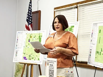
KINSMAN -- Officials and residents from several northeastern Trumbull County communities had the chance to let their voices be heard not by speaking but by putting dots on maps of what they feel is important for development of a countywide comprehensive land-use plan.
The Trumbull County Planning Commission hosted the first of several meetings Thursday on future land use throughout the county.
More than 50 officials and residents gathered inside the Kinsman Township Hall to hear about the planning commission's efforts to their communities.
Julie Green, director of the planning commission, said a $50,000 Ohio Department of Natural Resources grant is helping with costs for an initiative to see what communities want in a land-use plan to be used by the entire county.
"We are excited to get started on this important work on behalf of the townships, villages and cities in Trumbull County. This plan will be of benefit to the entire county,” Green said.
She said the dots people placed on maps of locations or items in the different communities will provide feedback as the land use-plan is developed.
Green said some communities have outdated land-use plans and others no plan at all.
She said northeastern Trumbull communities such as Kinsman, Vernon, Hartford, Cortland, Bazetta, Orangeville, Johnston, Gustavus and Fowler were part of the first meeting.
"We want your input to develop this plan to help elected officials to shape the future of these townships, villages and cities,” Green said.
Zachary Steiner, planning coordinator, said there will be other meetings for communities in other parts of the county.
Green said the plan "will be a roadmap to the future of your community" on how to protect and develop farmland, transportation, infrastructure, housing and natural areas.
She said the county has not completed a countywide land use plan for decades.
"Every community large or small will have the chance to have your voices heard and your priorities recorded. ... The county has 220,000 acres of farmland and in the past 30 years we have lost about 60,000 acres," Green said. "Farmland is a priority we want to focus on as part of this plan."
She said the plan will include maps and data on how land in different communities is used, in order to protect agricultural lands,
"This plan will help guide officials to make better decisions for the long term -- focused on health, safety and sustainability,” Green said.
The land-use planning process is being coordinated by the planning commission and GIS Man Development on behalf of the Trumbull County Commissioners and is funded through the Ohio Department of Agriculture's Land Use Planning Grant Program.
The project will include an analysis of existing land-use plans, community outreach, public surveys and the development of a final action plan with recommendations based on information collected throughout the process.
Officials said public participation will play an important role in helping identify priorities and guide the future of land use throughout Trumbull County.
The planning commission will work with GIS Man Development and bring back ideas to the officials and residents at planned follow-up meetings.
Steiner said the planning commission is also asking people to take a survey about what they want to see for land use.
Steiner said there will be 12 meetings total planned in different quadrants of the county. He said the next meeting will be in the southeastern section of the county.
PLACING DOTS
Throughout the hall there were large maps of several communities that people could place their dots on important areas,
Susan Dunbar of Vernon said she was glad the meeting took place and public participation was encouraged.
"I'm glad they will take our input. I'm interested in seeing what research will be done. Hopefully we will have a good outcome,” Dunbar said.
Jim Davies of Hartford said, "I think it is important that all of us get involved, These maps represent what we really feel."
Hartford Trustee Melissa Pucak said she drove directly from work to be at the meeting.
"It is important to make sure we respect what we have and maintain safety for our residents. We need to preserve and maintain our farmland, residential areas and forestry areas,” she said.
Melissa Miller of Kinsman, whose family has a farm in the northeastern part of the township, said it was great the public had the opportunity to provide input in a hands-on way.
"We want to be part of the process to get the plan in place that will benefit the entire county,” Miller said.